Innovative Major Streets Plans
Street Typologies and Realms
Every community is empowered by Missouri law to enforce a major street plan. This right to influence new developments gives communities the ability to create a comprehensive and consistent transportation system. However, a community will only receive this benefit if its major street plan is clear and well developed. The planning efforts associated with a major street plan pay dividends to a community.
Design Standards
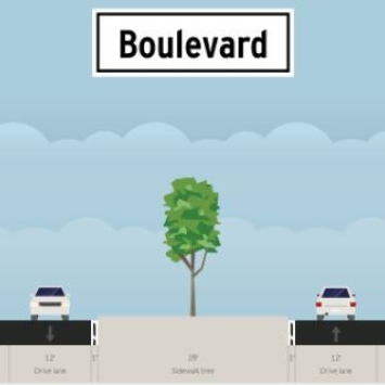
A major street plan always contains a map, but it should also include design standards. It is not only important to have roadways connecting the right places, but it is also important for them to provide the right services. Design guides provide the community with a mechanism to create streets with spaces for cars, bikes, buses, people and nature.
See how OTO's ROW requirements stack up against acquired ROW throughout the region, with an interactive map. Zoom in for interactive content. Click on a line to learn more.
Street Typologies
Design standards typically divide roads based on functional classification, but they can also include more site-specific typologies. Street typologies should account for the different land uses found found along the roadway and the types of trips commonly on that roadway. A street primarily used to connect neighborhoods would need a different design than one designed to connect major commercial nodes. Below are links to communities that are trying to implement innovative Street Typology elements along with their major streets plans.
Street Typologies can become even more flexible by including Street Realms, discussed next.
Example Policies: Street Typologies
Street Realms
The concept of Street Realms is fairly new. It was developed to help communities better communicate design expectations for roads in developed area, redeveloping areas, and undeveloped areas. Each area has different land use constraints and as such, different amounts of space are available for cars, bikes, people, and nature. Street Realms provide examples of how a road's "pedestrian realm" might be designed, given different land use constraints. The City of San Antonio did a great job of developing Street Realms in its SA Tommorrow Multi-modal Transportation Plan. The Street Realm portion of the plan is available below.
Example Policy: Street Realms
By developing clear street typologies and realms, OTO's communities can ensure the transportation network serves all users and has clear, context sensitive expectations for the local development community.