Safe Streets and Roads for OTO
Destination Safe Streets
The Safety Action Plan was approved by the Board of Directors on January 16, 2025.
Explore the High Injury Network
Explore a map of the highest crash locations throughout the region. Public comments received earlier in the process are also visible on top of these layers.
-
The information contained in these draft documents will be incorporated into the final plan.
Virtual Stakeholder Meeting Recording - 4/18/2024
OTO Awarded SS4A Grant!
On February 1, 2023, the U.S. Department of Transportation announced that the Ozarks Transportation Organization was awarded a Safe Streets and Roads for All grant, in the amount of $228,800. This grant will provide support for the development of a comprehensive Safety Action Plan. With this plan in place, OTO member jurisdictions will be able to apply for implementation grant funding in future years. We will be updating this webpage with further information as the project progresses.
This webpage contains information and links supporting our application and relating to the planning capacity of the Ozarks Transportation Organization, as well as ongoing efforts throughout the OTO region that support the development of a Safety Action Plan. This page, as well as information found throughout the OTO website, provides insight on our commitment to safety, public input, and the ability to deliver a quality Safety Action Plan. Click here to see more details about Action Plans versus Implementation Grants.
About the Ozarks Transportation Organization
The Ozarks Transportation Organization (OTO) is the regional Metropolitan Planning Organization for the Springfield region. The MPO, located in southwest Missouri, includes elected and appointed officials from Christian and Greene counties and the cities of Battlefield, Nixa, Ozark, Republic, Springfield, Strafford, and Willard. The OTO has identified safety as the number one priority in its planning process. The OTO is submitting the application to write a Safe Streets and Roads for All Action Plan for the OTO membership.
The OTO has consistently developed its own planning documents and is familiar with using consultants and purchased data as needed. Please visit the most recently adopted long range transportation plan, Destination 2045, to view how OTO can take extensive public input, diverse needs, and varied data to create a comprehensive, prioritized, and actionable transportation plan. We have also used visualization and web-based tools to develop an immersive experience.
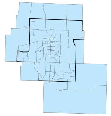
OTO Census Tracts
Using the methods described in the Notice of Funding Opportunity, the 2019 OTO Census Tract population is 368,479 persons.
The estimated 2019 population for the OTO planning area, available in this online map, is 330,016. The underserved population by census tract, 65,515, lies fully in the OTO boundary. To the left is a map showing the OTO boundary and relevant census tracts.
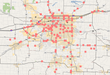
Fatal Crashes in the OTO Area from 2016 to 2020
Crash data was obtained via the same method described above for population, with 222 fatal crashes between 2016 and 2020. Crash data was sourced from the Missouri Department of Transportation and their internal Data Zone crash statistics map.
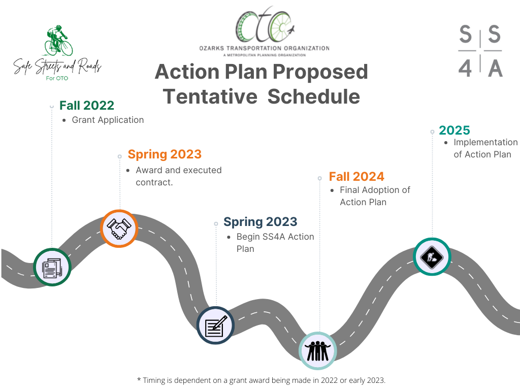
Plan Timeline
The OTO proposes an 18-month timeline for plan development.
Public Input Tools
The OTO has made a concerted effort to provide the public with multiple avenues for input. We have a dedicated website linked through http://giveusyourinput.org, which redirects to https://www.ozarkstransportation.org/give-us-your-input. Recent press releases are highlighted. The public can visually share and respond to concerns through an interactive map. OTO has a presence on Facebook and Twitter. We also have a specific email address for the public – comment@ozarkstransportation.org. All comments are shared with Technical Planning Committee members and Board members in a standardized format in each agenda. OTO recently launched a new web portal for the Transportation Improvement Program that also allows the public to directly comment on individual projects with proposed changes.
The Public Participation Plan recommends how and when the OTO engages the public, as well as recommending tools to improve that engagement. Annually, staff evaluates the PPP and makes further recommendations for improvement.
Complete Streets
The OTO Design standards included in the long-range plan, Destination 2045, recommended pedestrian and bicycle accommodations on a number of roadway classifications. Guidelines for those accommodations are currently included in the Design Standards. The OTO maintains a Complete Street Toolbox with links to resources for member jurisdictions complete street policy development. The OTO was commended for the creation of this toolbox during the 2021 Federal Certification Review.
Climate Change, Resiliency, and the Environment
The OTO area participates in the Ozone and PM Advance Programs. Analysis of impacts on environmental justice communities is a part of the regular planning process. The OTO assesses projects through its in-house EnviroSmart program, a database which includes both natural and environmental justice-related elements and was developed in consultation with Missouri Department of Natural Resources, Missouri Department of Conservation, Missouri State Parks, the State Historic Preservation Office, and MoDOT, with additional resources from US EPA, US DOT, and the US Census. The OTO mapped minority, low-income, disabled, and elderly populations against the location of projects in its Destination 2045 long range planning process to ensure that environmental justice was factored into the planning process.
Culture of Safety and Performance Measures
Since its creation as a TMA, the Ozarks Transportation Organization has actively used crash data to prioritize its Long Range Transportation Plan (LRTP) and Transportation Improvement Plan (TIP) projects and has tracked this as a locally developed performance measure since 2011. This is highlighted in the annual state of transportation report, as seen in the report for 2021.
Additionally, OTO has participated in the Missouri Blueprint for Roadway Safety/Southwest Coalition for Roadway Safety since its inception. OTO also stepped up for the region when it helped create a Traffic Incident Management (TIM) committee. This group is comprised of emergency responders and meets quarterly to build relationships, improve response times, and ensure responder safety. This cooperation also makes the region’s roads safer for the traveling public. The TIM committee coordinated with the Coalition for Roadway Safety to access funding to supply high-visibility vests for incident responders.
Innovative Technology
The region has a strong partnership in the Transportation Management Center (TMC), jointly operated by MoDOT and the City of Springfield. Together they have made great efforts to use ITS and other technology to promote safety throughout the region. A summary of TMC Operations can be found here.
Several years ago, MoDOT took part in the FHWA Every Day Counts 5 (EDC-5) initiative, which focused on a Crowdsourcing for Operations Peer Exchange. Now, MoDOT is part of the EDC-6 initiative focusing on Crowdsourcing for Advancing Operations, putting lessons learned into practice. In particular, the TMC is receiving Waze events into the ATMS software, whereby TMC operators can utilize CCTV cameras to view the event, enter the verified incident into their Event Management, and send Motor Assist personnel, if necessary.
Effort is underway to develop infrastructure to vehicle communications. The TMC has partnered with Traffic Technology Services (TTS) for them to receive real-time traffic signal timing from the TMC Transparity Central Signal Software, which can be shown within the vehicle display. An example in action would be when a traffic signal is red and shares a countdown of how much time will remain until the signal changes to green.
Fiber is continually being deployed to improve coverage and convert wireless connections at signals throughout the region. Over the past 3 years, MoDOT and the City of Springfield have installed 22 CCTV cameras at new locations and 30 more are planned, awaiting delivery. Such deployments allow better coverage for detecting and managing incidents, enabling signal engineers a view of real-time traffic to make signal timing modifications, and to provide the public with views of weather-related impacts to road conditions.
The City of Springfield has installed advance detection to measure arrivals on green and to collect volume and speed data to improve traffic flow and enhance safety at 34 intersections with plans for an additional 26 approaches by the end of 2022.
Accessible pedestrian signals have been installed at a total of 53 city-maintained signals, with an additional 25 planned for installation by the end of 2023. Leading pedestrian intervals have been implemented at 67 City of Springfield-maintained intersections, while flashing yellow arrow left turn signals have been installed at 47 locations.
While CCTV camera footage is not recorded, traffic data such as volumes and speed studies are shared with the Police Department to help focus enforcement efforts. This has evolved into a traffic count and speed study website.
Bicycle and Pedestrian Safety
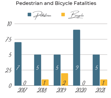
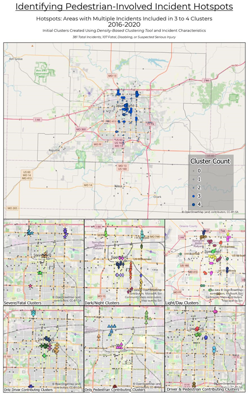
OTO intends to include a bicycle and pedestrian focus in the Safety Action Plan. As shown in the State of Transportation Report, pedestrian fatalities experienced a recent peak in 2020, when daily vehicle miles traveled per capita were at a similarly recent low. To better understand the contributing factors and trends behind these deaths, OTO has undertaken an analysis of all pedestrian-involved incidents between 2016 and 2020. This information and process will be helpful to developing the Safety Action Plan for the region. The map on the next page highlights some of the results.
According to the Ozarks Alliance to End Homelessness, 581 persons were considered unsheltered in January 2021. This population is especially vulnerable to roadway safety, often on foot or bike. It will be important that this Safety Action Plan involve representatives for this group, as well as propose action items that benefit a mobile population.